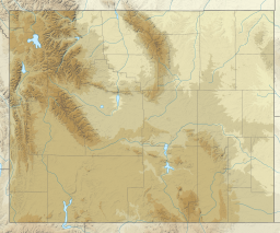
Pathfinder Reservoir
| Pathfinder Reservoir | |
|---|---|
| Location | Carbon / Natrona counties, Wyoming, United States |
| Coordinates | 42°28′05″N 106°51′14″W / 42.46806°N 106.85389°W |
| Type | reservoir |
| Primary inflows | North Platte River |
| Primary outflows | North Platte River |
| Basin countries | United States |
| Max. depth | 192 feet (59 m)[1] |
| Water volume | 1,016,000 acre⋅ft (1.253 km3) |
| Shore length1 | 117 mi (188 km) |
| Surface elevation | 5,846 ft (1,782 m) |
| 1 Shore length is not a well-defined measure. | |
Pathfinder Reservoir is located in the U.S. state of Wyoming on the North Platte River between Casper and Rawlins. It sits 47 miles (76 km) southwest of Casper, in Carbon County and Natrona County. The reservoir was created by Pathfinder Dam and has a storage capacity of 1,016,000 acre-feet (1.253×10⁹ m3). The shoreline consists of 117 miles (188 km). Much of the water used to serve the 335,000 acre (1360 km2) North Platte Project is stored here. Some of the water in the reservoir is released to satisfy other water rights and to operate power plants downstream of the reservoir. Much of the Pathfinder Reservoir is included in the Pathfinder National Wildlife Refuge. Pathfinder Reservoir is the site of the only established population of the Macedonian Ohrid Trout (S. letnica) in the United States.[2]
Climate
[edit]According to the Köppen Climate Classification system, Pathfinder Reservoir has a cold semi-arid climate, abbreviated "BSk" on climate maps. The hottest temperature recorded at Pathfinder Reservoir was 100 °F (38 °C) on July 14, 1925, July 12-13, 1954, July 22, 1960, and July 7-9, 1989, while the coldest temperature recorded was −39 °F (−39 °C) on January 17, 1930.[3]
| Climate data for Pathfinder Dam, Wyoming, 1991–2020 normals, extremes 1905–present | |||||||||||||
|---|---|---|---|---|---|---|---|---|---|---|---|---|---|
| Month | Jan | Feb | Mar | Apr | May | Jun | Jul | Aug | Sep | Oct | Nov | Dec | Year |
| Record high °F (°C) | 59 (15) |
67 (19) |
72 (22) |
82 (28) |
89 (32) |
98 (37) |
100 (38) |
99 (37) |
95 (35) |
88 (31) |
75 (24) |
64 (18) |
100 (38) |
| Mean maximum °F (°C) | 45.0 (7.2) |
48.6 (9.2) |
62.1 (16.7) |
72.5 (22.5) |
80.1 (26.7) |
91.1 (32.8) |
94.2 (34.6) |
92.9 (33.8) |
88.9 (31.6) |
75.5 (24.2) |
62.8 (17.1) |
49.7 (9.8) |
95.0 (35.0) |
| Mean daily maximum °F (°C) | 33.0 (0.6) |
35.6 (2.0) |
45.6 (7.6) |
53.7 (12.1) |
64.2 (17.9) |
76.5 (24.7) |
85.5 (29.7) |
83.0 (28.3) |
72.8 (22.7) |
58.1 (14.5) |
44.8 (7.1) |
33.3 (0.7) |
57.2 (14.0) |
| Daily mean °F (°C) | 24.6 (−4.1) |
26.1 (−3.3) |
36.0 (2.2) |
42.7 (5.9) |
52.4 (11.3) |
63.3 (17.4) |
71.7 (22.1) |
69.9 (21.1) |
60.2 (15.7) |
47.2 (8.4) |
36.0 (2.2) |
25.5 (−3.6) |
46.3 (7.9) |
| Mean daily minimum °F (°C) | 16.3 (−8.7) |
16.6 (−8.6) |
26.4 (−3.1) |
31.8 (−0.1) |
40.5 (4.7) |
50.1 (10.1) |
57.9 (14.4) |
56.8 (13.8) |
47.7 (8.7) |
36.3 (2.4) |
27.2 (−2.7) |
17.7 (−7.9) |
35.4 (1.9) |
| Mean minimum °F (°C) | −7.7 (−22.1) |
−6.9 (−21.6) |
3.9 (−15.6) |
16.1 (−8.8) |
28.3 (−2.1) |
39.7 (4.3) |
48.9 (9.4) |
45.8 (7.7) |
36.5 (2.5) |
18.8 (−7.3) |
7.6 (−13.6) |
−6.0 (−21.1) |
−14.3 (−25.7) |
| Record low °F (°C) | −39 (−39) |
−35 (−37) |
−33 (−36) |
−5 (−21) |
15 (−9) |
22 (−6) |
33 (1) |
27 (−3) |
13 (−11) |
−7 (−22) |
−20 (−29) |
−34 (−37) |
−39 (−39) |
| Average precipitation inches (mm) | 0.58 (15) |
0.48 (12) |
0.83 (21) |
1.24 (31) |
1.93 (49) |
1.37 (35) |
0.74 (19) |
1.05 (27) |
0.83 (21) |
1.13 (29) |
0.49 (12) |
0.53 (13) |
11.20 (284) |
| Average snowfall inches (cm) | 3.2 (8.1) |
4.6 (12) |
5.8 (15) |
4.5 (11) |
1.0 (2.5) |
0.1 (0.25) |
0.0 (0.0) |
0.0 (0.0) |
0.1 (0.25) |
1.7 (4.3) |
3.6 (9.1) |
4.0 (10) |
28.6 (72.5) |
| Average precipitation days (≥ 0.01 in) | 6.9 | 6.6 | 7.5 | 10.2 | 10.8 | 7.8 | 7.2 | 5.9 | 6.3 | 8.2 | 5.8 | 7.8 | 91.0 |
| Average snowy days (≥ 0.1 in) | 3.6 | 4.0 | 4.1 | 2.6 | 0.5 | 0.0 | 0.0 | 0.0 | 0.1 | 1.3 | 2.8 | 3.6 | 22.6 |
| Source 1: NOAA[4] | |||||||||||||
| Source 2: National Weather Service (WRCC mean maxima, mean minima, average snowfall, NWS snowy days 1905–present)[3][5] | |||||||||||||
See also
[edit]References
[edit]- ^ "Pathfinder Reservoir, Wyoming, USA".
- ^ Fuller, Pam; Neilson, Matthew (June 2015). "The U.S. Geological Survey's Nonindigenous Aquatic Species Database: over thirty years of tracking introduced aquatic species in the United States (and counting)". Management of Biological Invasions. 6 (2): 159–170. doi:10.3391/mbi.2015.6.2.06. ISSN 1989-8649.
- ^ a b "NOAA Online Weather Data". National Weather Service.
- ^ "U.S. Climate Normals Quick Access". National Oceanic and Atmospheric Administration. Retrieved August 20, 2022.
- ^ "Period of Record Climate Summary". Western Regional Climate Center.
External links
[edit]- U.S. Geological Survey Geographic Names Information System: Pathfinder Reservoir
- Pathfinder Reservoir bottom topography map


