Province of Viterbo
Province of Viterbo | |
|---|---|
 Palazzo dei Papi (Palazzo Papale), in Viterbo | |
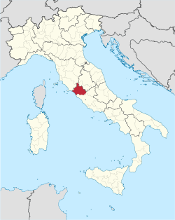
 Map with the province of Viterbo, in red, in Italy | |
| Country | |
| Region | Lazio |
| Capital | Viterbo |
| Comuni | 60 |
| Government | |
| • President | Alessandro Romoli (FI) |
| Area | |
| • Total | 3,615.24 km2 (1,395.85 sq mi) |
| Population (30 April 2017)[2] | |
| • Total | 318,163 |
| • Density | 88/km2 (230/sq mi) |
| GDP | |
| • Total | €6.559 billion (2015) |
| • Per capita | €20,425 (2015) |
| Time zone | UTC+1 (CET) |
| • Summer (DST) | UTC+2 (CEST) |
| Postal code | 01100, 010xx |
| Telephone prefix | 0761, 0763, 0766, 06 |
| Vehicle registration | VT |
| ISTAT | 056 |
| Website | Official website |
The province of Viterbo (Italian: provincia di Viterbo) is a province in the Lazio region of Italy. Its capital is the city of Viterbo.[4]
Geography
[edit]Viterbo is the most northerly of the provinces of Lazio. It is bordered to the south by the Metropolitan City of Rome Capital and to the south-east by the province of Rieti. It is also bordered by the regions of Tuscany (province of Grosseto) to the north and by Umbria (province of Terni) to the east. The Tyrrhenian Sea is located to the west.[5]
The territory falls in and makes up the largest part of the historical region of Tuscia, with the name sometimes being used synonymously with that of the province.
As of 2017, the province has a total population of 318,163 inhabitants over an area of 3,615.24 square kilometres (1,395.85 sq mi), giving it a population density of 89.05 inhabitants per square kilometre. The provincial president is Marcello Meroi and the province contains 60 comuni (municipalities).[4]
The territory of the Province of Viterbo can be roughly divided into four geographical areas:
- the coastal and flat area of the Lazio Maremma;
- the Alta Tuscia, which is more hilly and has a volcanic origin, corresponding to the areas near Tuscany and Lake Bolsena;
- the area of the Cimini Mountains around Lake Vico and the regions bordering the metropolitan city of Rome;
- lastly, the eastern part bordering Umbria, encompassing the areas bathed by the Tiber River.
It can be said that the city of Viterbo geographically belongs both to the Alta Tuscia and the Cimini area, as it is located right below the mountains, yet at a short distance from Lake Bolsena.
History
[edit]This section needs expansion with: history from 1800s as part of the Province of Rome is missing. You can help by adding to it. (January 2019) |

The area of the province of Viterbo contained a number of Etruscan cities including Tuscania, Vetralla, Tarquinia, and Viterbo.[6] Viterbo was conquered by the Roman Republic in 310 BCE; despite this, minimal information is known of the city until it was utilised in 773 CE by Desiderius, King of the Lombards, as a base against the Holy Roman Empire. Matilda of Tuscany gifted the city to the papacy in the 11th century. Frederick Barbarossa was based in Viterbo as he planned to invade Rome in 1153, and he conquered the city in 1160 while preparing to attack Rome.[6]
After a period as a free commune, in the early 13th century Viterbo became part of the Papal States.[6] The Knights of Saint John were expelled from Rhodes in the 16th century and were temporarily granted refuge in Viterbo before they could travel to Malta. Pope Paul III described himself as a citizen of Viterbo and formed a university in the city. It joined the Kingdom of Italy on 12 September 1870 and during World War II, Viterbo was heavily bombed.[6]
Gallery
[edit]-
Viterbo, Palazzo dei Papi (Palazzo Papale)
-
Panorama of the walls of Civita Castellana
-
Tarquinia, wall painting in the Tomb of the Leopards
References
[edit]- ^ "Provincia di Viterbo" (in Italian). Tuttitalia.it. Retrieved 23 February 2017.
- ^ "Statistiche demografiche ISTAT" (in Italian). Demo.istat.it. Retrieved 10 September 2017.
- ^ Regions and Cities > Regional Statistics > Regional Economy > Regional Gross Domestic Product (Small regions TL3), OECD.Stats. Accessed on 16 November 2018.
- ^ a b "Provincia di Viterbo". Tutt Italia. Retrieved 19 August 2015.
- ^ "Viterbo". Italia.it. Retrieved 19 August 2015.
- ^ a b c d Roy Palmer Domenico (2002). The Regions of Italy: A Reference Guide to History and Culture. Greenwood Publishing Group. p. 151. ISBN 978-0-313-30733-1.
External links
[edit]- Official website (in Italian)


